

NORTH Shropshire could escape the worst effects of rising sea levels, data from a new mapping tool suggests.
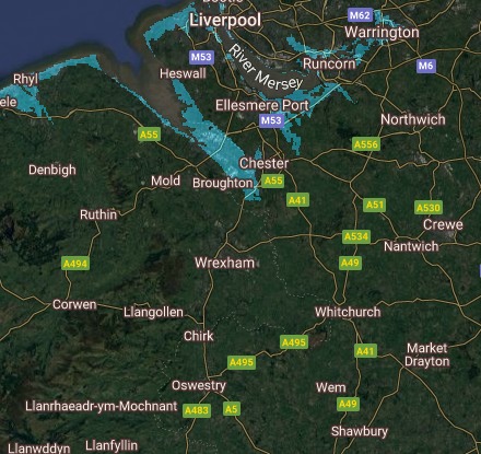
According to a study by Climate Central, much of the North Wales coast and Wirral could be flooded, if current pollution levels and global warming continue.
But using the interactive mapping tool by climate Central, north Shropshire will escape flooding from rising sea levels.
Sea levels by 2050
How rising sea levels could impact the North Wales and Wirral coast by 2050
A worst case scenario situation of artic ice sheets melting and raising sea levels by 15 metres could see the River Dee up to Bangor-on-Dee flooded, which could in turn impact north Shropshire.
Although north Shropshire will likely escape the effects of rising sea levels, large annual storms will continue to affect the region, with a record number of deaths and injuries caused by flooding and other water emergencies in Shropshire last year.
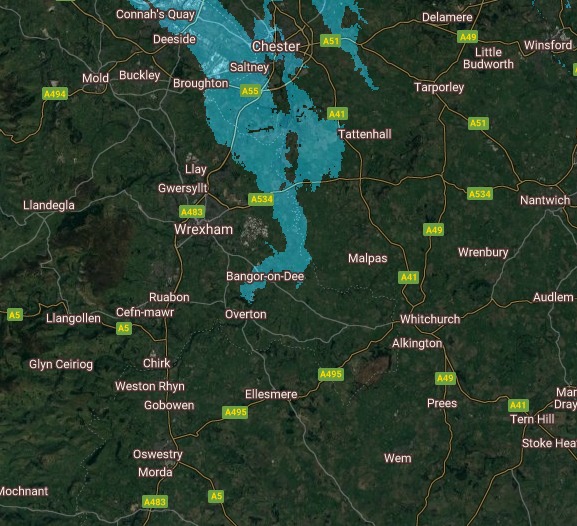
A 'worst case scenario' of Arctic ice sheets melting
A worst case scenario of a 15m rise in sea levels
Home Office data shows that in Shropshire, 22 deaths or injuries occurred in incidents where firefighters were called to flooding or other water emergencies in 2019-20.
This was the highest number since comparable records began in 2010-11, and up from eight in 2018-19.
To view the interactive flood map and the various datasets, visit coastal.climatecentral.org/map


Comments: Our rules
We want our comments to be a lively and valuable part of our community - a place where readers can debate and engage with the most important local issues. The ability to comment on our stories is a privilege, not a right, however, and that privilege may be withdrawn if it is abused or misused.
Please report any comments that break our rules.
Read the rules here